This area at the north of the Cumberland Hospital Precinct and running along the bank of the Parramatta River and darling Mills Creek is most often associated with the 36 acres granted to Samuel Marsden.[1] The land included a portion of Marsden purchased from Charles Smith who occupied land in this area from 1792 to around 1800. [2] The land title handed over to Marsden was recorded by Governor Lachlan Macquarie as being thirty-six acres on 25 August 1812. According to these records the farm was,
bounded on the South East side by part of Bligh’s Farm, On the South West and North sides by the Parramatta River and on the East side by a Deep Dyke designed as a Mill Race …59
After Marsden acquired it the area was commonly referred to as ‘Mill Dam Farm’ because of the water mill (one of the Colony’s earliest) which Marsden erected sometime between 1810 and 1811 near the junction of the Darling Mills and Toongabbie creeks.[3]
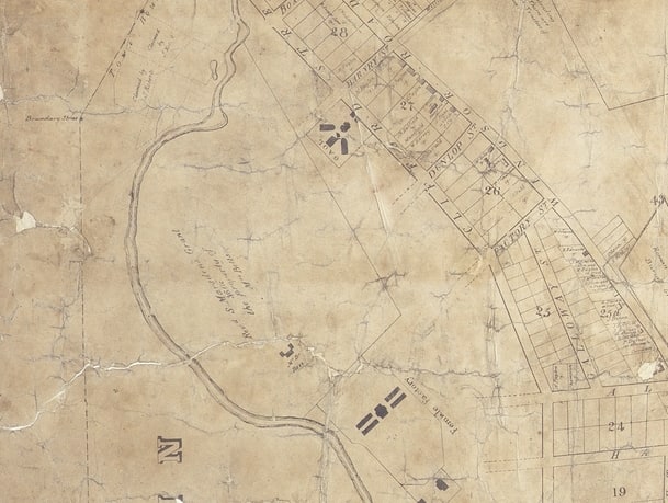
According to an archaeological report conducted in 2009 there are two principal sites associated with this grant. They are the site of the old water mill (including its original cottage, workers buildings and the mill) and the old farm house.[4] However there appear to be other sites of interest also sprinkled across this area. One of these is mentioned in the subdivision map of the site drawn up for James Byrnes in 1841. This map includes the location of the old mill and cottages as well as citing a quarry on what appears to be ‘Darling Mills Creek, (although marked Parramatta River on this map). [5]
Given all this information you would think locating these sites would be easy but the intervening 150 years of reuse of the site, and in some areas long term neglect, have made identification of the sites difficult.
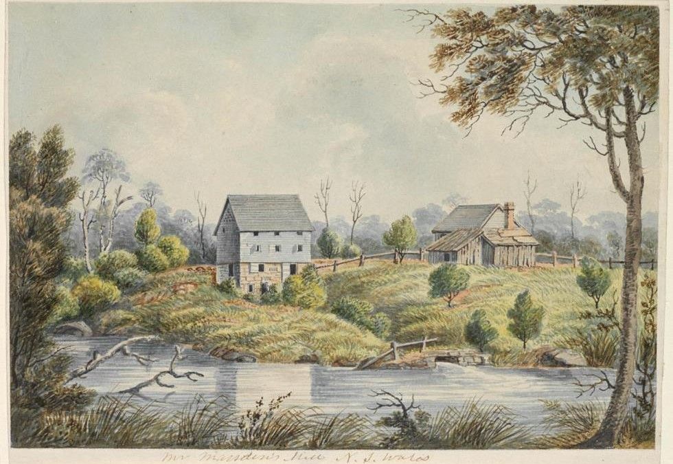
One of the key sources for identifying of possible sites is a painting credited to John Lycett and done around 1820. In this shot we can clearly see Marsden’s three story mill house and the associated cottage at what looks like the juncture of the Parramatta River and Darling Mills Creek.
Given the nice open space surrounding the building in the picture and its relationship to the river it would seem easy to identify this site. But when we paid a visit to the site in early 2015 it became clear why this was not so easy.
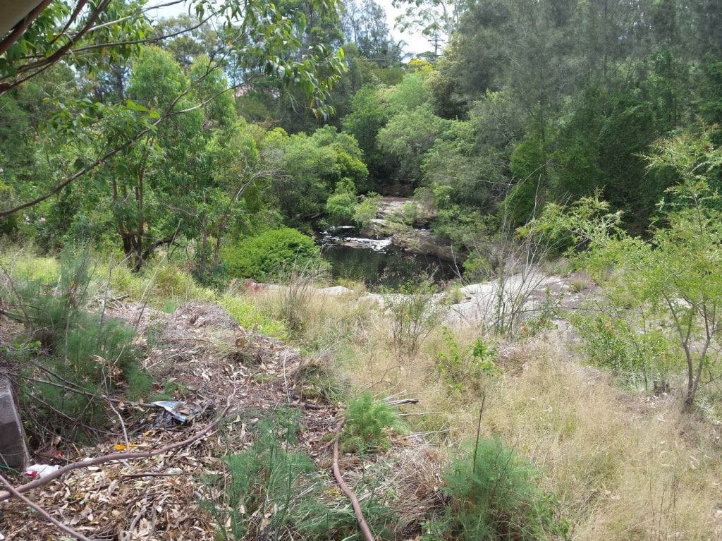
Continuous use of some parts of the site and neglect and the resulting overgrowth was one problem (illustrated by this picture below). Another is the actual levels of the river have changed as weirs, dams and floods have changed the contours of the river and its water levels. These floods also appear to have washed away remnants of the original structures. In his 1933 history of Parramatta, James Jervis notes that the weir Marsden built across Darling Mills Creek to supply water to the mill-race was washed away in a flood.[6]
This was not the first mill in to try to utilise the water from the upper reaches of the river but the earlier Government Mill, situated further downstream was not a success. Instead Marsden selected this location to take advantage of the improved water flow, secure foundations while his experience in the construction of the Government Mill, helped him make his decision. The mill seems to have been more of a success and remained in operation at least until 1838 when he died.
Marsden also established a vineyard on part of the land he had purchased from Charles Smith and this area became known as Vineyard Farm. In 1841 James Byrnes made the following comments on the quality of the soil and the significance of the site for the wine making industry in Australia, as he felt it was,[7]
his duty to acquaint them that the soil in this property is of the best description, and peculiarly adapted for gardening purposes. As proof of this he has merely to site that it was in this part of the colony that the cultivation of grapes was first crowned with success, and at present the proprietors vineyard, which adjoins the land now advertised, contains upwards of five thousand vines.
Marsden’s daughter Mary appears to have moved onto the site after her marriage to John Betts in 1830 and they built a house at the southern extremity of near the Female Factory.[8]
In 1841 they attempted to subdivide and resell the land but this failed and instead they were forced to sell the remaining land to John Blaxland in June 1842 for 2000 pounds A number of sale notices appeared from late 1841 through to June 1842 which described the Vineyard and Old Mill farm. [9]
The Australian newspaper description from 1842 made it clear the mill was no longer in operation but that the allotment of about half an acre comprised of,
the site of the old flour mill, the stone foundations and timbers of which are in a good state of preservation, and with some few repairs could be converted into an excellent residence, the land having been heretofore cultivated, with water frontage, and made very easily into a capital nursery.[10]

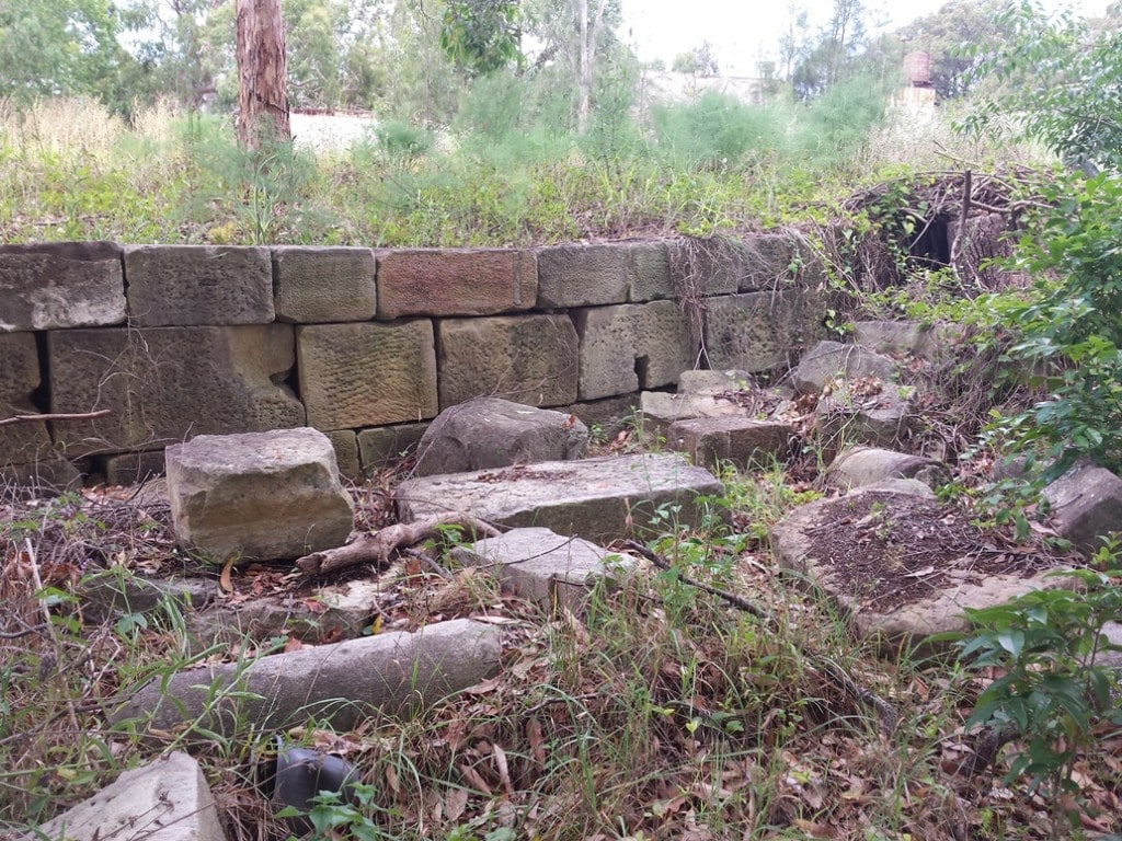
North Parramatta, Sandstone Remnants, Old Mill Farm Precinct, Parramatta City Council, image by Geoff Barker, 2014
Another site of interest is the quarry located on the banks of Darling Mills Creek and which appears to have provided ‘freestone’ for the building of the mill and presumably other buildings on the site. When offered for sale in 1841 this quarry was cited as being … reserved for public purposes.[11]
As we can see from the images above there are a number of archaeological features scattered around the site which may once have used stone quarried the side of the creek bed.
The Blaxland land was eventually acquired by the government as part of the Parramatta Lunatic Asylum in 1866 and from this date had a number of Asylum buildings erected on it. Other parts continued to be farmed and landscaped as it was integrated into the asylum grounds. In 1872 Mrs Betts’ house was occupied by the Medical Superintendent of the asylum. It continued to be used as a residence into the 20th century before being demolished in 1948.
by Geoff Barker, Research and Collections Services Coordinator, Parramatta City Council Heritage centre, 2015
References
[1] Higginbotham and Associates, Cumberland Hospital, Fleet Street, North Parramatta Archaeological Management Plan (Historical Sites) for Conservation Management Plan, for Sydney West Area Heath Service, 2009, p.22
[2] Higginbotham and Associates, Cumberland Hospital, Fleet Street, North Parramatta Archaeological Management Plan (Historical Sites) for Conservation Management Plan, for Sydney West Area Heath Service, 2009, p.22
[3] The Story of Parramatta and District, James Jervis, Shakespeare head Press, 1933, p.42
[4] Higginbotham and Associates, Cumberland Hospital, Fleet Street, North Parramatta Archaeological Management Plan (Historical Sites) for Conservation Management Plan, for Sydney West Area Heath Service, 2009, p.23
[5] Map, Plan of Vineyard or Old Mill Dam Farm, 1841, nla p-f159-e
[6] The Story of Parramatta and District, James Jervis, Shakespeare head Press, 1933, p.42
[7] Australasian Chronicle, Tuesday 14 December 1841, page 4
[8] Higginbotham and Associates, Cumberland Hospital, Fleet Street, North Parramatta Archaeological Management Plan (Historical Sites) for Conservation Management Plan, for Sydney West Area Heath Service, 2009, p.24
[9] The Australian, Tuesday 14 June 1842, page 3
[10] The Australian, Tuesday 14 June 1842, page 3
[11] Australasian Chronicle, Tuesday 14 December 1841, page 4

This work by Parramatta City Council, Research and Collection Services is licensed under a Creative Commons Attribution-ShareAlike 4.0 International License.
Based on a work at http://arc.parracity.nsw.gov.au/about/contact_details/.
Permissions beyond the scope of this license may be available at https://sites.google.com/site/hervicenquiries/home.


