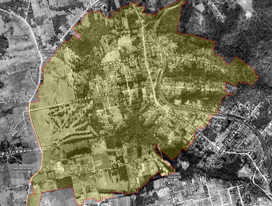
1943 aerial photograph of Beecroft. Source: Six Maps
Beecroft is a 5.1km2 suburb in northern Sydney bounded by the Hills (M2) Motorway in the north, the waterway in the east, generally by Plympton Road, Norwood Avenue, Karril Avenue and North Rocks Road in the south, and generally by Pennant Hills Road and Maher Close in the west. As of 12 May 2016, it has been divided between the Hornsby Shire Council and the City of Parramatta Council (as indicated in the above feature image) local government area. It was part of the Pennant Hills district and is surrounded by neighbouring suburbs Carlingford and Cheltenham.
Traditional Custodians – The Wallumetta (land) and Wallumedegal People
The area of Beecroft is situated on land that has traditionally been inhabitated by the Wallumedegal people, associated with the Dharug language group, whose lands stretched across the Sydney basin.
European Settlement and the Field of Mars Common
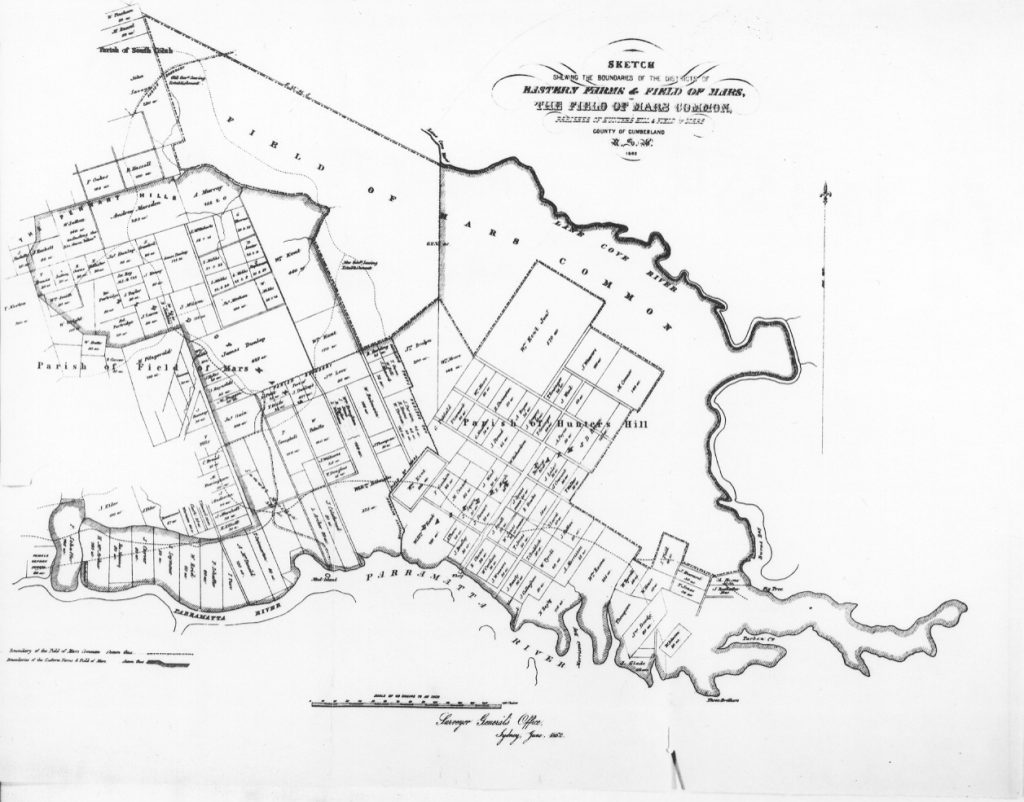
Beecroft was originally part of the Field of Mars Common. The Field of Mars Common was 5,050 acres in 1804 (later more than 6,000 acres) of common land bounded to the south by the Parramatta River and to the north by Boundary Road in the Ryde area set aside by Governor Philip Gidley King (1758-1808) for the use of the local community. It was named by King after land grants made to marines. In 1831, it was the centre of timber harvesting and remained undeveloped until the Field of Mars Resumption Act of 1874 which enabled the colonial government to clear and subdivide the land. By the mid 1880s most of the land was sold for small farms, orchards and villas. 85 acres 2 roads and 28 perches were set aside as a cemetery. More than half that area was later converted into the Field of Mars Flora and Fauna Reserve and the Field of Mars cemetery is now 17 hectares. The Macquarie Park Cemetery was also originally part of the Field of Mars Common. 45 hectares remain as the Field of Mars Reserve and Wildlife Refuge.

Map of Field of Mars, 1862 (Source: Hornsby Shire (2017). In Hornsby Shire Recollects. Retrieved from https://hornsbyshire.recollect.net.au/nodes/view/1711
Naming of Beecroft
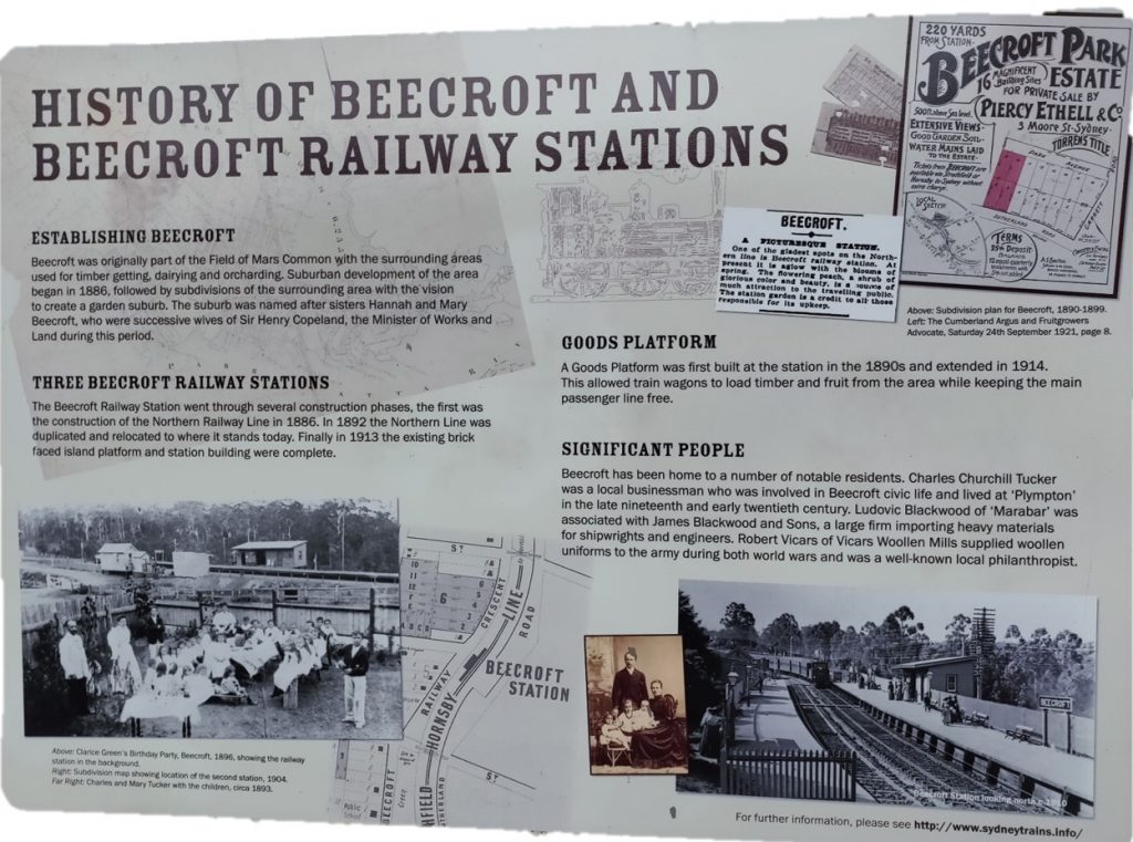
The coming of the Northern railway line between Strathfield to Hornsby led to the development of suburb of Beecroft. The Beecroft section was officially declared open on 17 September 1886. The origin of the suburb name stems from the maiden name of the wives of then Minister for Lands, the Honourable Sir Henry Copeland (1839-1904). Sir Copeland had commissioned a survey of the area done for residential purposes and decided to name the new suburb after the maiden name of his wives, Hannah and Mary, two sisters whom he married in succession. Their names have also been used in the naming of the suburb’s east-west streets: Hannah Street, Copeland Road and Mary Street. Coincidentally, Mr W. Abra of the Italian Bee Company later settled in Beecroft in 1889 where he established a bee farm which led to many to incorrectly assume the suburb was named after this farm.

History of Beecroft and Beecroft Railway Stations sign outside Beecroft Station on 15 Wongala Crescent, Beecroft. (Photograph by Anne Tsang, 2019).
Chronological timeline of the history of Beecroft
- mid 1800s – temperance movement in Beecroft led to the village never having a hotel
- 1890 – Beecroft Post Office opened on 10 February 1890
- 1893 – the newly formed Beecroft Progress Association suggested that seven unsold allotments totalling 23 acres along the north side of Devlins Creek should be set aside as Beecroft Park. https://www.bchg.org.au/index.php/en/environment/parks/beecroft-and-chilworth/21-beecroft-and-chilworth-reserve
- 1896/97 – Beecroft Public School was established in 1896 at 90-96 Beecroft Road, Beecroft, NSW 2119. The oldest building on the site dates from 1897 with addition school brick buildings dating to circa 1920’s. https://www.environment.nsw.gov.au/heritageapp/ViewHeritageItemDetails.aspx?ID=1780205. At present Beecroft has four Primary Schools, an independent Anglican school and a high school on the border of Carlingford.
- 1897 – Trustees for the Beecroft reserve were appointed
- 1903 – the Village Green was ‘opened’ on 5 September 1903 by the Governor Sir Harry Rawson who travelled to Beecroft by train. Over 2000 people were present and this was ‘the largest gathering seen in Beecroft to this date.” The Governor inspected a guard of school cadets and a troop of police and lancers from the Parramatta Barracks. https://www.bchg.org.au/index.php/en/environment/parks/village-green
- 1904 – Beecroft School of Arts built on the corner of now 111 Beecroft Road, Beecroft, NSW 2119. In 1910, the Federation period building had large extensions made to the existing foundation by Hornsby architect L S Robertson. It was later converted into the current Beecroft Community Centre. https://www.environment.nsw.gov.au/heritageapp/ViewHeritageItemDetails.aspx?ID=1780176
- 1914 – fire station
- 1922 – Arden Anglican School commenced. It was a preparatory school for the Presbyterian Ladies’ College, Croydon, arising from the initiative of the Beecroft Presbyterian Church and commenced in the Beecroft Presbyterian Church Hall in Welham Street. Initially it had 13 students. Its first principal was Mrs Eleanor Linck who had previously been teaching in England.
- 1923 – the first purpose built post office. It is located on the corner of 5B Hannah Street, Beecroft, NSW 2119 https://www.environment.nsw.gov.au/heritageapp/ViewHeritageItemDetails.aspx?ID=1780214 image: Beecroft Post Office, NSW, June 1986. https://livinghistories.newcastle.edu.au/nodes/view/86371 by Sternbeck, Percival William, 1921-2004; https://hornsbyshire.recollect.net.au/nodes/view/3441
- 1938 – the Byles family donated five acres to be known as Chilworth Reserve, as a flora and fauna sanctuary, under the care of the Wildlife Preservation society,
- 1942 – Chilworth Reserve was handed over to Hornsby Shire Council with covenants on the title to protect the bushland. The Byles family’s love of the Australian bush also led to Baldur Byles erecting a sign near the scout hall at the end of Welham Street which read ‘Practise good manners in the bush. You are welcome’. https://www.environment.nsw.gov.au/heritageapp/ViewHeritageItemDetails.aspx?ID=1780968
- 1953 – another valuable donation of land came from Evelyn St Ives McConnell behind Finlay Avenue on the south side of Devlins Creek.
- 1954 – Hornsby Council acquires the adjoining block of bush for Beecroft Reserve
- 1958 – inception of Beecroft Cheltenham Civic Trust which has been very active in the preservation of the bushland and amenity of Beecroft
- 1959 – John Noble, who had moved to a new home in Fiona Road in 1949, petitioned Hornsby Council to add a strip of land behind houses in Austral Avenue to Beecrodt reserve.
- 1965 – proposed transport link
- 1966 – Roselea Community Centre at 647 – 671 Pennant Hills Road, Beecroft, evolved from the Carlingford Progress Association, to meet the growing sporting, social and cultural needs of the rapidly increasing Carlingford District. The small hall at the Roselea Community Centre was completed in June 1966 and officially opened August 1966. The second and third stages were combined and construction was completed early 1972. The large hall was then opened officially on 20 May 1972. The complex is located in Roselea Reserve, which is on the eastern side of Pennant Hills Rd, between North Rocks Rd and the M2 motorway. The Roselea Complex consists of two halls. It has disabled toilet facilities available for both halls and off street parking for about 66 cars. http://www.venuebat.com.au/venues/roselea-community-centre
- 1967 – A patch of land formally belonging to Beecroft Public School was added to Chilworth Reserve
- 1969 – An unformed area of Mary Street through to York Street was added to Chilworth Reserve
- 1988 – election of a Liberal National coalition government led by Premier Nick Greiner. The new state government declared that they were ‘a road building government’ and announced a public/private partnership would build a tollway from North Ryde to the northwest, with the route to go directly through the Beecroft Reserve and other areas of bushland in Marsfield and North Ryde. This proposal, supported by the local member Bruce Baird, who was Minister for Transport, divided the Beecroft Cheltenham Civic Trust membership and was a critical issue for the future of the Trust. Despite strong opposition by groups of citizens who formed themselves into a Coalition of Tollway Action Groups, and two formal inquiries,
- 1997 – the M2 was finally built and opened. Although the route was moved southward from the original alignment which, if implemented, would have destroyed the Chilworth Reserve. This battle for the Beecroft Reserve raised issues about preservation of land which had been thought to be protected.
- 2011 – M2 widening by one lane in each direction commenced in March 2011. This will see further loss and disturbance to the bushland in Beecroft Reserve.
![]() Anne Tsang, Research Assistant, Parramatta Heritage Centre, City of Parramatta, 2020
Anne Tsang, Research Assistant, Parramatta Heritage Centre, City of Parramatta, 2020
References
- Beecroft Cheltenham History Group. (2015). Beecroft and Chilworth Reserve. Retrieved from https://www.bchg.org.au/index.php/en/environment/parks/beecroft-and-chilworth/21-beecroft-and-chilworth-reserve
- Jagielski, J. (2015, March 28). Secret suburb: take a trip to Beecroft, a very special community village, The Sunday Telegraph. Retrieved from https://www.dailytelegraph.com.au/news/nsw/secret-suburb-take-a-trip-to-beecroft-a-very-special-community-village/news-story/761e41ebf4f366e81dc39d9250d87072
- Read, P. (1996). Losing a Neighbourhood. In Returning to Nothing: The Meaning of Lost Places (pp. 172-195). Cambridge: Cambridge University Press. doi:10.1017/CBO9781139085069.010
Further resources on Beecroft
- Beecroft and Cheltenham : the shaping of a Sydney community to 1914 / by Beecroft-Cheltenham History Group. Shelf Number LS 994.41 BEE. Publication Date 1995
- From fruit bowl farms to housing boom : Beecroft Carlingford Epping subdivisions / compiled by Chris Staples. Shelf Number LS 994.41 FROM V1 Publication Date 2018
- Street names of Pennant Hills and surrounding suburbs of Beecroft, Cheltenham, Cherrybrook, Thornleigh, Westleigh and West Pennant Hills / by Trevor G. Patrick,Shelf Number LS 919.441 PATR Publication Date 1994
- Sydney’s suburbs : how and why they were named / by Ken Anderson. Shelf Number LS 994.41 AND Publication Date 1989
- Tales of Beecroft / by Carmichael, Dorothy. Shelf Number LS 994.41 CARM Publication Date 1981


