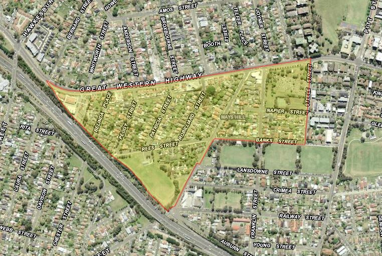
A small suburb to the south-west of Parramatta CBD, the area is administered by Cumberland Council and the City of Parramatta. The boundaries of the triangular shaped suburb are the Great Western Highway, Steele Street, Banks Street, Burnett Street and the Western Motorway, however only the easterly portion of the suburb of Mays Hill lies within the Parramatta LGA. The area within Parramatta is bounded by the Great Western Highway to the north, Burnett Street to the west, Banks Street to the south and Steele Street to the east and forms part of Rosehill Ward.
This mainly residential suburb had a total population of 767 in 2016 most of whom lived in detached houses with a small number of medium density dwellings. [1]
European history of the Parramatta District began in April 1788 with an exploration party led by Governor Arthur Phillip, which travelled along the Parramatta River to the vicinity of The Crescent and decided upon the site of the future town of Parramatta. By November that year, the governor had established an outpost consisting of convicts and marines on the site. The settlers observed a landscape dominated by tall open forest now known as Cumberland Plain Woodland with area of mangroves, saltmarsh and wetlands along the riverbanks with an abundance of wildlife. [2]
For thousands of years the land around Parramatta was home, hunting ground and meeting place for members of the Burramattagal clan of the Darug people. European settlers cleared the land seriously diminishing the supply of native plants and animals on which Aboriginal people relied for their existence. [3]
Early Land Grants
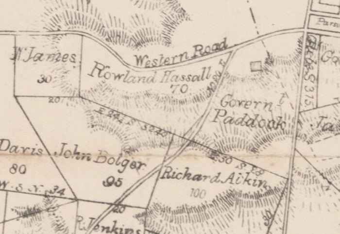
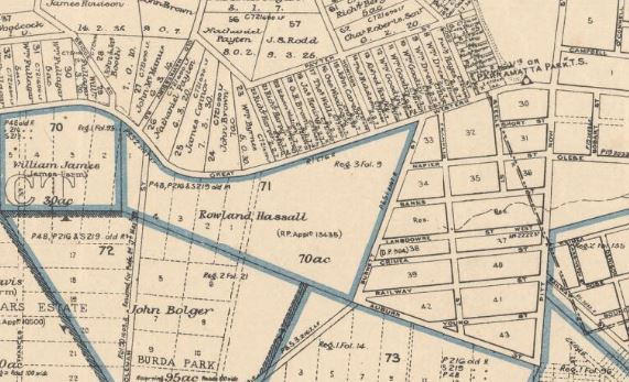
Some of the first land grants in the area south of the Western Road include John Bolger’s 95 acres (38.5 hectares) in 1810 and Rowland Hassall’s 70 acre (28 hectare) grant in 1818. [4]. Portions 32, 33, 34 and 35 were later purchased by George Oakes and now form part of the City of Parramatta. [5]
Excerpt from Parish of St John, County of Cumberland map prior to 1859 [MAP F 360] showing early grants in the Mays Hill area including Rowland Hassall’s grant of January 1818. Retrieved on 1/03/2020 from http://nla.gov.au/nla.obj-229950258/view
Excerpt from the Parish of St John County of Cumberland map showing the land grants of Rowland Hassall, John Bolger and the land purchased by Oakes. Retrieved on 1/03/2020 from http://nla.gov.au/nla.obj-233835406/view
The Western Road (now the Great Western Highway) is the oldest thoroughfare through the Parramatta area, the first section having been constructed in 1793. In 1817, a toll-bar was constructed along the Western Road near present day Mays Hill. The road was extended at this time from Parramatta to the Nepean River at Penrith forming a link with the new road over the Blue Mountains. [6]
The name of the suburb is thought to have been derived from the country estate of wealthy and influential Sydney businessman Thomas May whose association with the Parramatta are commenced in 1859. However, the painting c. 1840 attributed to G. E. Peacock established that the elevated area on the Western Road overlooking Parramatta was already known as Mays Hill at this time. [7]
After the subdivision of land in the former Governor’s or Parramatta Domain in 1859, May took the opportunity to purchase a one acre block overlooking Parramatta Park and the river on which he constructed a substantial complex of buildings known as Park Lodge. [8]
The estate included detached stables, coach house, laundry and bakehouse, and the grounds were landscaped with flower and vegetable gardens and an orchard. May had operated several successful businesses in Sydney including wheelwright and publican, slaughterhouse as well as being a property owner and developer. May and his family resided at Park Lodge until May’s death in 1873. [9]
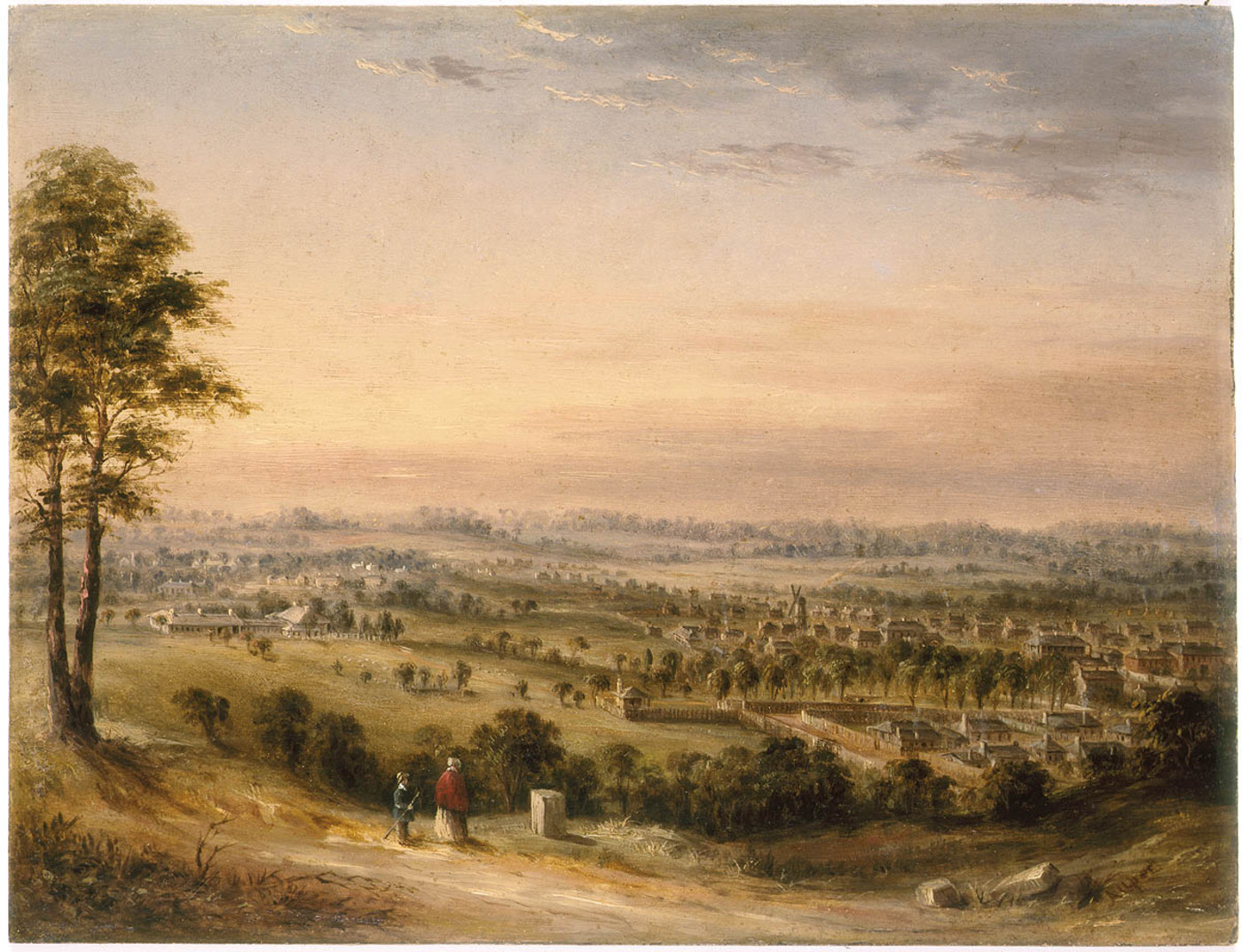 View of the town of Parramatta from May’s Hill, ca. 1840. Painting attributed to G. E. Peacock. Retrieved on 2/03/2020 from the Mitchell Library, State Library of NSW. http://digital.sl.nsw.gov.au/delivery/DeliveryManagerServlet?embedded=true&toolbar=false&dps_pid=IE3153634&_ga=2.260801421.1085604941.1569814154-1299290293.1493691472
May’s Hill Cemetery
The Western Road Cemetery also known as the May’s Hill Cemetery on the Great Western Highway began as two separate grants in 1839 and 1849 as a cemetery for Presbyterians and Baptists. In later years members of seven other religious denominations were also included in the interments: – Methodists, Congregationalists, Seventh-Day Adventists, Latter Day Saints, Salvation Army and the Brethren. After the closure of St John’s in central Parramatta member of the Church of England were also buried at Mays Hill. The Presbyterian section of the cemetery contains many of Scottish ancestry including James Houison and many members of his family. [10]
Mays Hill Recreation Reserve adjacent to the cemetery was dedicated in 1884 and the reserve now encompasses the entire block bounded by the Great Western Highway, Steele Street, Napier Street and Franklin Street. [11]
Subdivision and Development
Prior to World War Two there was very little subdivision of the Mays Hill area. Residential dwellings were clustered around the Banks, Franklin and Burnett Streets. During the 1940s, land was subdivided, roads were formed and new homes were constructed. Advertisements extolled the virtues of the area that promised “a grand panoramic view of the city of Parramatta & surrounding districts”. [12]
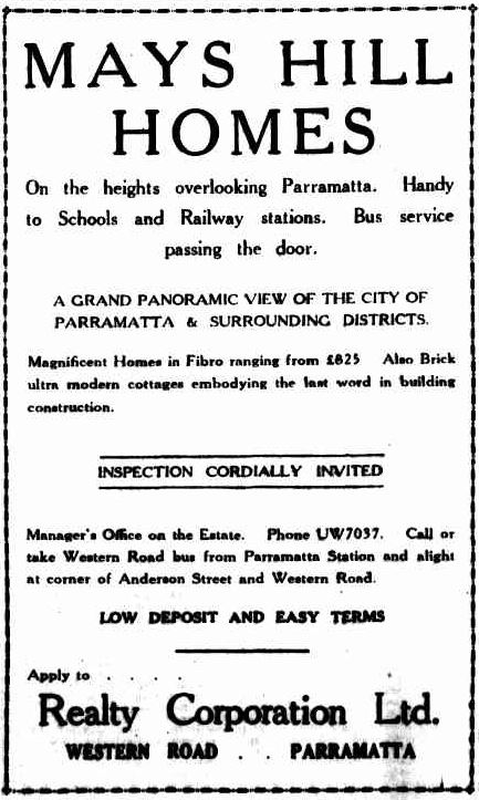 Advertisement for new homes near the Western Road (now the Great Western Highway). Retrieved on 1/03/2020 from https://trove.nla.gov.au/newspaper/article/106196498 The Cumberland Argus and Fruitgrower’s Advocate, 17 April 1940 p. 7. Advertising.
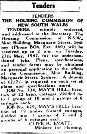
In the late 1940s, the Housing Commission of New South Wales commenced construction of public housing in the Parramatta area including Mays Hill constructing brick and fibro dwellings on land which was previously undeveloped. The role of the commission was to construct housing of an acceptable standard available “to ensure the best possible home conditions…for the home-occupier”. [13] The streets were well-formed, kerbed and guttered and the layout of the suburb was carefully planned. A minimum lot size, frontage and distance between the dwellings was planned to afford the best possible environment “for the future citizens of these new communities”. Areas were also set aside in each development for public recreation. [14]
Typical home built by the Housing Commission of NSW in the 1940s. Retrieved on 2/03/2020 from Decoration and glass. Vol. 13 No. 1 (May – June 1947). p. 20./ https://nla.gov.au/nla.obj-370960072/view?sectionId=nla.obj-372799925&partId=nla.obj-371083900#page/n11/mode/1up
Retrieved on 1/03/2020 from The Cumberland Argus and Fruitgrower’s Advocate, 21 May 1947 p. 10 Advertising. https://trove.nla.gov.au/newspaper/article/105731279
Many of the original houses still exist in the suburb of Mays Hill today although some single dwellings have been replaced by medium density townhouses and unit blocks due to a trend towards higher density residential living in Western Sydney.
Neera Sahni, Research Services Leader & Cathy McHardy, Research Assistant, City of Parramatta, Parramatta Heritage Centre, 2020.
References:
[1] ABS Statistics for Mays Hill 2016. Retrieved from https://quickstats.censusdata.abs.gov.au/census_services/getproduct/census/2016/quickstat/SSC12538
[2] History of Waterways. Retrieved from https://www.cityofparramatta.nsw.gov.au/recreation-environment/waterways/catchment-management/history-of-waterways
[3] Guider, M. (2003). Aboriginal History of Parramatta. Parramatta: Author. p. 6.
[4} Excerpt from Parish of St John, County of Cumberland [prior to 1859]. Retrieved from http://nla.gov.au/nla.obj-229950258/view
[5] Excerpt from the Parish of St John, County of Cumberland. Retrieved from http://nla.gov.au/nla.obj-233835406/view
[6] Elias, J. (2013). Holroyd: Girraween, Greystanes, Guildford, Mays Hill, Merrylands, Pemulwuy, Pendle Hill, Prospect, Smithfield, Toongabbie, Wentworthville, Westmead, Woodpark, Yennora. Alexandria, N.S.W Kingsclear Books. p. 17.
[7] View of the town of Parramatta from May’s Hill, ca. 1840. Retrieved on 2/10/2019 from the Mitchell Library, State Library of NSW. http://digital.sl.nsw.gov.au/delivery/DeliveryManagerServlet?embedded=true&toolbar=false&dps_pid=IE3153634&_ga=2.260801421.1085604941.1569814154-1299290293.1493691472
[8] Varman, R. V. J. P. (2001). Park Lodge: an archaeological assessment of above ground and below ground remains. Kellaway Constructions Pty Ltd. p. 16 Retrieved from
[9] Elias, J. (2013). Holroyd: Girraween, Greystanes, Guildford, Mays Hill, Merrylands, Pemulwuy, Pendle Hill, Prospect, Smithfield, Toongabbie, Wentworthville, Westmead, Woodpark, Yennora. Alexandria, N.S.W Kingsclear Books. p. 29.
[10] McClymont, J. (2001). Pictorial History: Parramatta and District. Alexandria: Kingsclear Books. p. 40.
[11] Mays Hill Reserve Plan of Management. Holroyd City Council. pps. 1, 2. Retrieved from https://www.cityofparramatta.nsw.gov.au/sites/council/files/2018-08/Mays%20Hill%20Reserve%20Plan%20of%20Management%202004.pdf
[12] Advertising. The Cumberland Argus and Fruitgrower’s Advocate, 1940, 17 April. p. 7. Retrieved from https://trove.nla.gov.au/newspaper/article/106196498
[13] The Housing Commission of NSW. Retrieved from Decoration and Glass. Vol. 13 No. 1 ( May – June 1947). p. 11.
[14] The Housing Commission of NSW. Retrieved from Decoration and Glass. Vol. 13 No. 1 (May – June 1947). p. 13.


