Situated between Hermington and Willoughby Streets in Epping, one will find a leafy park with picnic spots, playgrounds, sports courts, and two iconic bus shelters. The park is Loftus Square, and it is the oldest in the Epping district, celebrating its 140th anniversary in 2021. Join us as we look at records from our Council Archives and related historical resources to explore the history of the square.
The Traditional Owners of the area now known as Epping are the Wallumedegal Peoples. Aboriginal people lived for thousands of years in the Epping district.
European settlement commenced in Sydney in 1788. By 1792, it had extended to the Epping region with Governor Phillip granting parcels of land to marines. At this time, the area was known as the ‘Field of Mars.’ This was a reference to the Roman Field of Mars, a soggy field outside the city walls named after the Roman God of War. The area included the suburbs we now know as Epping, Ryde, and Marsfield.
Epping was an area that contained river flats, mangrove swamps and creeks – with many birds, shellfish, and edible bushfood plants part of the environment. The early land grants were made with a view of clearing parts of this land for the purposes of European agriculture. Convict labour, livestock and food from the public stores were provided to early settlers by the government so that processes for cultivating soil, planting grain and cropping could be established.
In 1804, Governor King further reserved an area of 6235 acres of land as a common within the Field of Mars for the use of settlers and personnel of the NSW Military Regiment. By the 1830s the grants in this area were being subdivided into orchard blocks due to the suitability of the soil for fruit growing. Examples of advertisements from the time can be seen here: The Sydney Herald, 7th March 1833, The Sydney Monitor, 10 September 1838 and The Australian, 4 June 1839. Fruitgrowing would become the prime industry in the Epping district – supplying fruit for the Sydney region and beyond right through to the 1960s.
In 1803 an Irish surveyor James Meehan, who had been transported to Australia for his part in the Irish Rebellion of 1798, was also granted 100 acres of land in the Field of Mars – known as “Brush Grove.” The land was used first for timber logging, and later orcharding. In the 80 years following James Meehan’s grant, the land would change hands several times before its eventual subdivision which paved the path for the creation of Loftus Square.
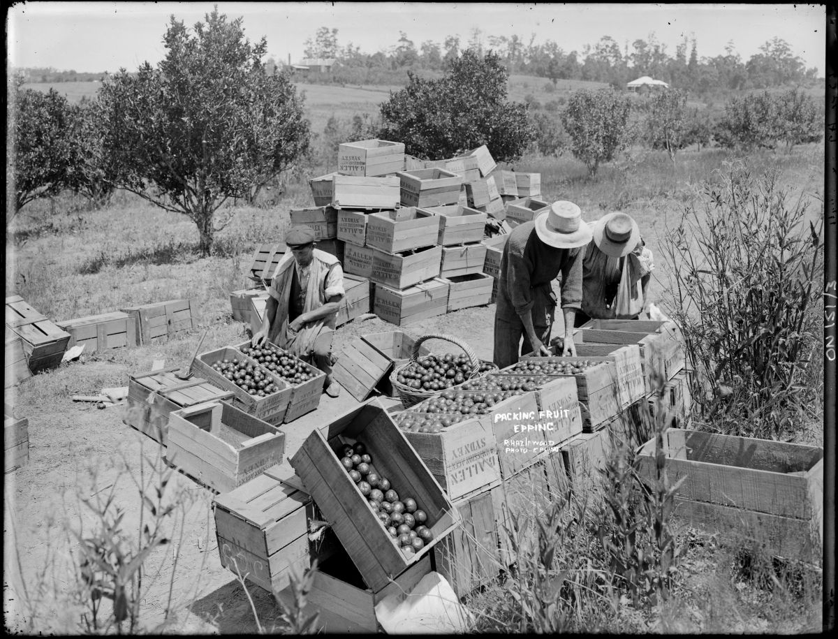
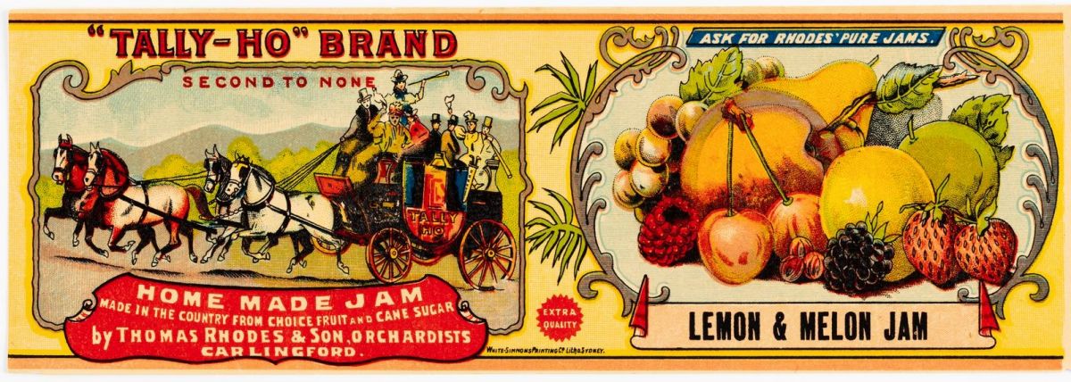
This label is associated with the Rhodes Family – orchardists and jam makers. The Rhodes Family lived in Brush Grove Estate, Epping.
In 1881, a proposal was submitted for the Great Northern Railway line to run between Sydney and Newcastle. It was one of the only major railway lines in NSW that had yet to be constructed, and part of the route included a stop at Epping, then known as East Carlingford. The railway would open five years later, in September 1886.
The proposed train line not only presented a new method for orchardists in the Epping area to export their fruit, but it also spurred the first residential subdivision in the area, Brush Grove Estate. The introduction of smaller blocks of land was intended to encourage ‘city people’ to consider making the move, with many advertisements of the time emphasising that Brush Grove was “within easy distance of the Metropolis [and] one of the most healthy desirable suburbs Sydney enjoys.”
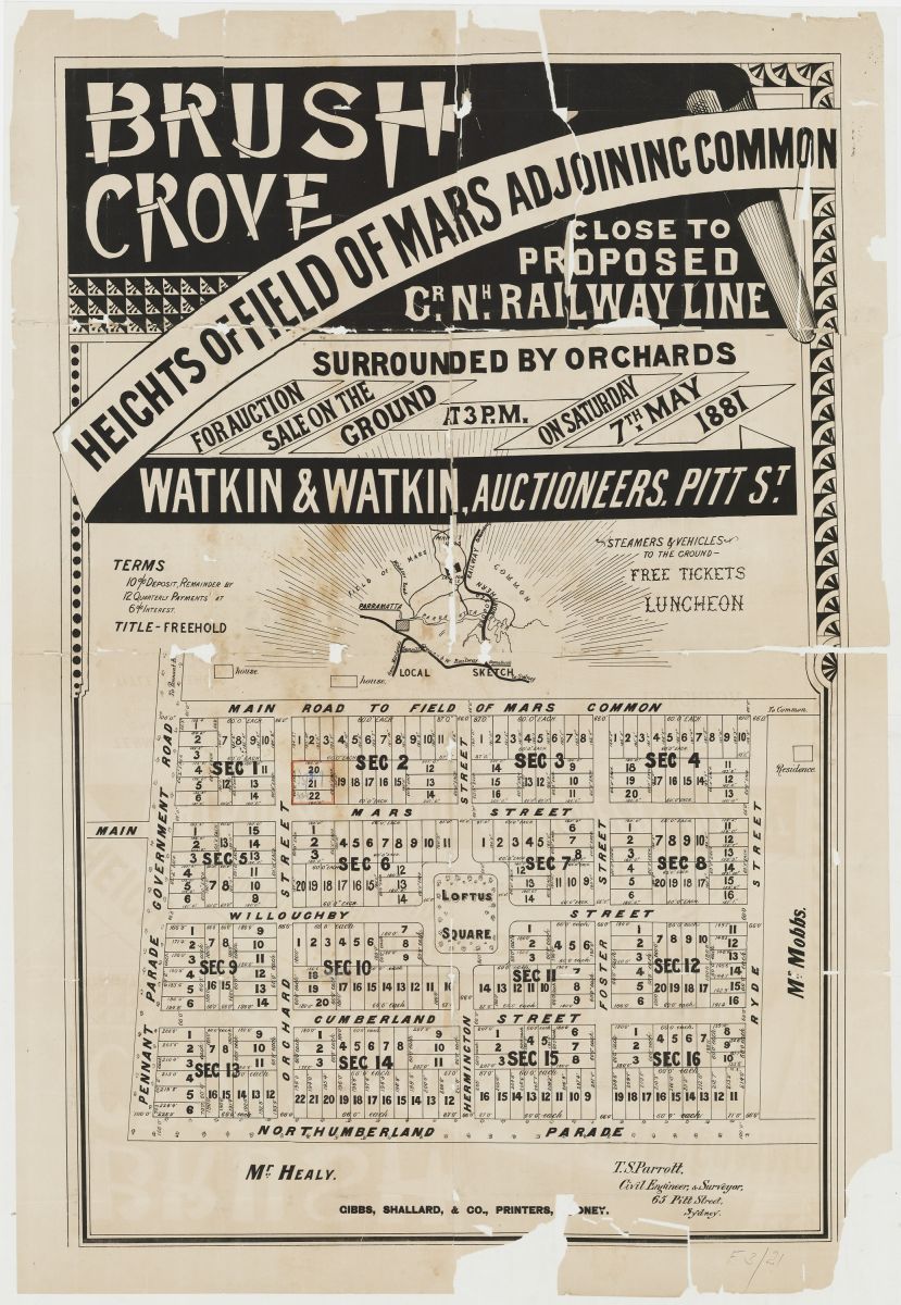
In the centre of Brush Grove Estate, another feature was introduced – the first park, Loftus Square. Loftus Square was set in the highest point of the Field of Mars and is still unique in the Parramatta LGA today as the only surviving example of a ‘rectilinear urban subdivision’ – designed to be geometrically centred around a public park. The square was named after Lord Loftus, the Governor of NSW between 1879 and 1885.
Loftus Square was initially privately owned. In 1889, Dundas Municipal Council was incorporated and the area containing Loftus Square fell under the boundaries of the Dundas LGA. By July 1891, Dundas Municipal Council had been in talks with James Henderson Wood, who owned the southern portion of the park, and Charles Heydon, who owned the northern portion, regarding whether they would transfer this land to the Council for public use. Charles Heydon reportedly agreed if the land would be used for “recreation purposes for all time.”
The following excerpt from the minutes of the meeting of Dundas Municipal Council, held at Dundas Town Hall on the 15th July 1891, references this event:
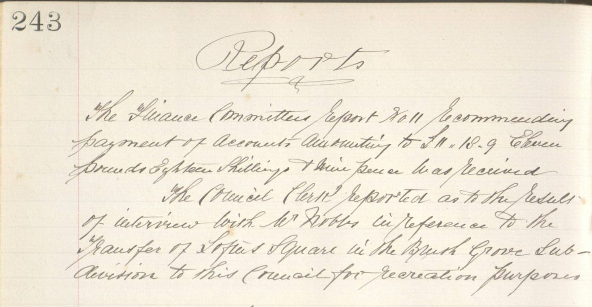
“The Council Clerk reported as to the result of interview with Mr Nobbs in reference to the transfer of Loftus Square in the Brush Grove sub-division to this Council for recreation purposes.”
The process of transferring the land would take six years to complete. The conveyancing work for Dundas Council appears to have been undertaken by John Nobbs, the former Mayor of Granville between 1887 and 1888. Between 1891 and 1897, John Nobbs had both filed for bankruptcy and had several unsuccessful attempts to return to parliament.
Newspaper articles of the time reflect the various events and negotiations surrounding the transfer to Dundas Municipal Council. In July 1892 John Nobbs stated that the deeds would be ready “in a few days.” However, in March 1893, while a transfer was arranged for Joseph Watkins’ portion of the square (transferred to him by J.D. Wood in the same year), John Nobbs’ own bankruptcy and political commitments had delayed registration. Meanwhile, negotiations with Charles Heydon regarding his portion appear to have continued until at least April & June of 1895. By March 1897, Dundas Council had sought the advice of their solicitor regarding the ‘non-conveyance’ of Loftus Square by John Nobbs. John Nobbs replied later that month that the delay had been caused by fees out of pocket totalling £8,8. With the fees paid, it was reported in the Council meeting dated 31st March 1897 that the registration was finally complete:
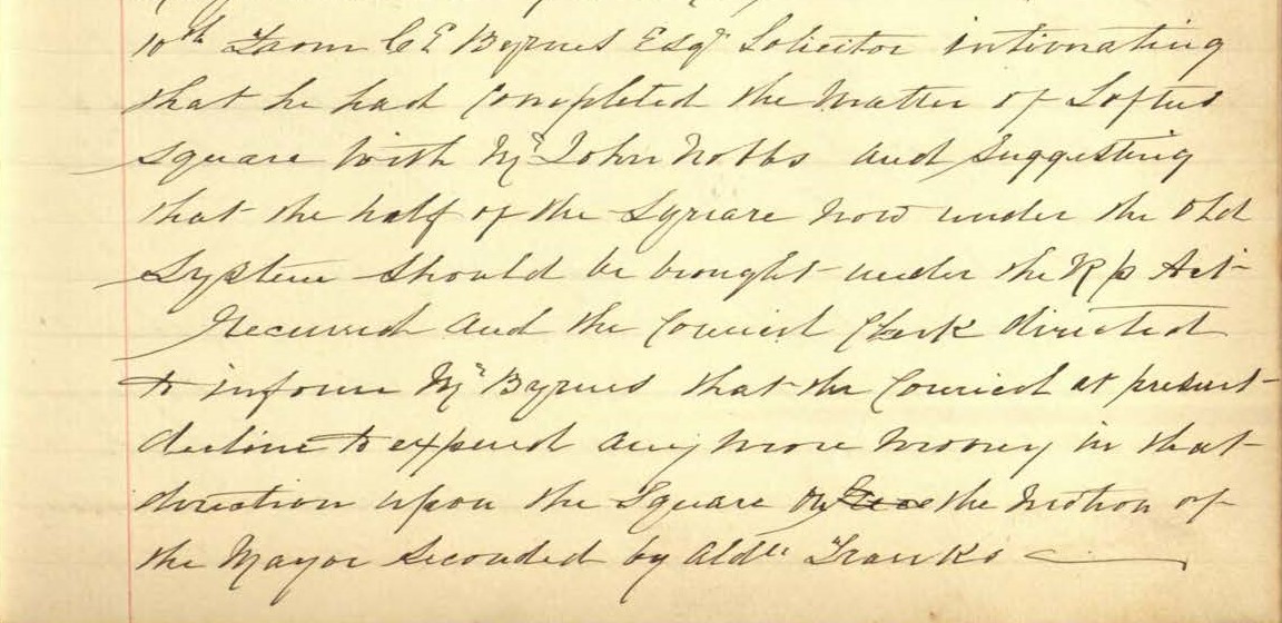
“10th: From CE Byrnes Esqr. [Esquire] Solicitor – intimating that he had completed the matter of Loftus Square with Mr John Nobbs and suggesting that the half of the Square now under the old system should be brought under the RP [Real Property] Act. Received and the Council Clerk directed to inform Mr Byrnes that the Council at present declines to expend any more money in that direction upon the Square on the Motion of the Mayor, seconded by Aldn. [Alderman] Franks.”
From 1897, the use of Loftus Square as a public recreation space was officially the responsibility of Dundas Municipal Council.
Cricket
One of the recreation activities associated with Loftus Square is cricket. Newspaper articles reflect that the park was referred to as the local cricket ground as early as 1897. In 1923, local citizens arranged for a concrete pitch to be laid in the centre of the park, which was used by the Carlingford Cricket Club.
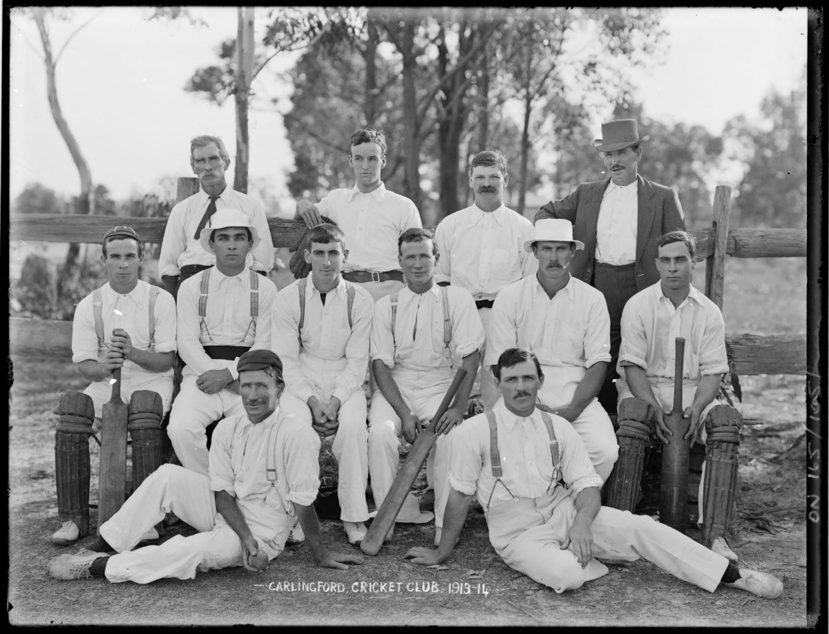
The Carlingford Cricket Club often hired the cricket pitch for their summer seasons, with Dundas Municipal Council charging between £3 - £5 for its use. Records in our Council Archives reflect that the fee was usually negotiated depending on how much maintenance was required for the cricket grounds (as some of this work appears to have been carried out by the club) as well as what other facilities were available.
The Council also faced challenges in supporting cricket at the park - Loftus Square was considered too small for a cricket ground – in 1923 it was reported that a stray cricket ball had knocked down a passing horse. Local residents had also complained about the ‘nuisance’ of Sunday cricket, and in 1925 games on a Sunday were restricted by the Council when Carlingford Cricket Club requested to hire the ground.
The cricket pitch remained in Loftus Park until the 1940s. In February 1940, Dundas Council resolved to make improvements to the park which resulted in Willoughby Street being extended through the centre – removing the cricket ground facilities. The Council Minutes of 7th February 1940 reflect this:
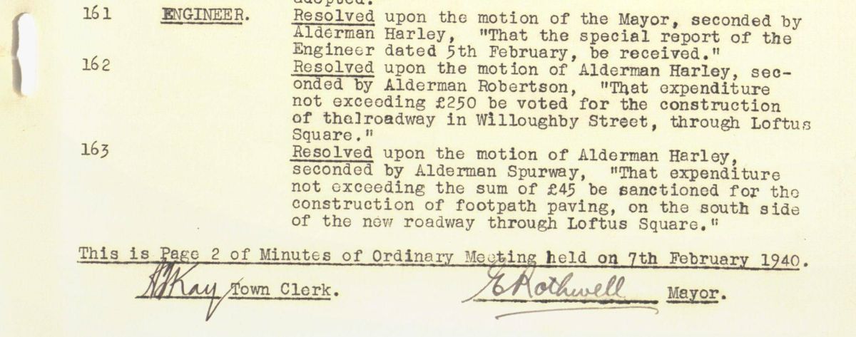
The extension of Willoughby Street through the centre of Loftus Park marked the division of the park into the two precincts that remain today.
Carnivals, Schools and Families
Loftus Square has been used over time by the community, schools, and families for a range of social activities. In 1895, the Guildford Presbyterian Sunday School had a “jolly day” out at the park which included children’s races, and games of cricket and rounders. By 1910, the park was highlighted as a source of “improved health and comfort” within the community and discussions arose around installing a children’s playground. The Park was used to host birthday parties, and various carnivals which included events such as local fundraisers and New Year’s Day celebrations.
In 1921, the Carlingford District Progress Association wrote to the Council to ask if they would consider obtaining more land for Loftus Square due to the growing population of the Epping district and the importance of the park as a recreation space for the children of the district. Below is an excerpt from the letter sent to the Council on the 7th June, 1921:
![Loftus Park [Incoming Correspondence Received by Dundas Municipal Council] City of Parramatta Archives: PRS72/063.](/sites/phh/files/inline-images/IMG_20220628_0001copy.jpg)
The cost to obtain land to extend the park was estimated to cost the Council more than £1000. Unfortunately, the Council did not have the funds and in 1922, they wrote to the NSW Department of Lands to request financial assistance of £500, as well as both the Carlingford District Progress Association and the West Epping District Progress Association to assist in fundraising. Unfortunately, the Council was unable to obtain the required funding and after a second attempt for financial assistance from the Department of Lands in 1923, the Council could take ‘no further steps’ regarding the acquisition of land for Loftus Park.
With the extension of Willoughby Street through the park in the 1940s, the Council resolved to use the new layout to have a children’s playground installed, and in 1941 the newly established parks committee recommended to the Council that swings be installed in Loftus Square.
In 1948, Dundas Municipal Council amalgamated with Parramatta City Council and the management of this recreation space fell under the predecessor of the Council we have today.
The use of the park has continued to evolve as a recreational and social venue. Today, the park contains playgrounds, recreational walking paths, basketball and netball facilities, and spaces for picnicking.
In addition to its use for social activities, the park is also an important green space. Loftus Square contains several historic trees such as blackbutts and stringy barks that predate the 1881 subdivision of Brush Grove Estate. In 1975, members of the Epping Civic Trust planted a stand of young eucalypts in the southwestern corner of the park. In 2009, the Loftus Square Park Committee planted a growth tree in the park, which has a measuring post next to it. This allows the Epping district's younger residents a chance to create their own piece of history - measuring their growth, but also that of the tree and changes to Loftus Square around them.
The Bus Shelters of Loftus Square
Another feature contained within Loftus Square are two Clement Cummings bus shelters on the opposite sides of Willoughby Street.
The shelters are iconic landmarks found across the ACT and were designed as part of the National Capital Development Commission in 1974.
The first shelter has had a home at the park for at least fifty years. In the late 1990s, the Loftus Square Park Committee undertook to have a mural painted on the bus stop that reflected the history of the Epping area.
In 2014, it was recognised that while commuters travelling one way had a shelter from the weather while waiting for transport, those heading in the opposite direction did not. The Council was contacted by the Epping Civic Trust Committee and the Loftus Square Park Committee and produced various designs for consideration for a shelter on the other side of the road. However, the designs were deemed too modern.
By a stroke of luck in 2015, an Epping Civic Trust Committee member was travelling on a train and spotted a concrete bus shelter in the railway yards adjoining Maitland Railway Station, that was a match for the design of the shelter already in the park. The bus shelter was not in great condition and required repairs, but after approaching the Maitland Station Master, they agreed to transfer the bus shelter to the City of Parramatta Council.
The Epping Civic Trust, Loftus Square Park Committee and the Council contributed funds for a structural engineer’s report, confirming that the shelter was structurally sound and could be transferred. The Council subsequently approved funding to relocate the shelter, and in 2015 it was installed in Willoughby Street.
To match the existing stop, mural artist Annette Barlow was commissioned to paint the shelter following guidelines supplied by the late historian Alex McAndrew, who assisted with the content design for the artworks depicted inside and outside both shelters. The outside design matches the colour scheme of the original shelter, and the inside depicts scenes taken from a photograph of a picnic in the park in 1922. In June 2017, the Loftus Square Park Committee officially unveiled the newly painted bus shelter:
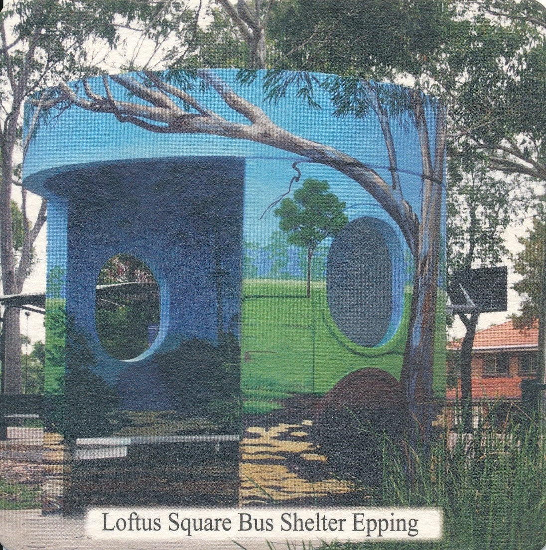
As iconic urban architectural designs with mural paintings relating to the history of the Epping area, the bus shelters are a unique feature to be found within Loftus Square.
Paige Davis, Archivist, City of Parramatta Council 2022
Select bibliography
Epping Civic Trust (November 2015) Epping Civic Trust Newsletter. Retrieved from: https://eppingcivictrust.org/wp-content/uploads/2018/03/ect-newsletter-nov-2015.pdf.
Epping Civic Trust (August 2017) Epping Civic Trust Newsletter. Retrieved from: https://eppingcivictrust.org/wp-content/uploads/2018/03/ect-newsletter-aug-2017.pdf.
Gee, S. “Are Canberra’s iconic bus shelters found anywhere else in the world?” ABC News, 8 Aug 2016. Retrieved from: https://www.abc.net.au/news/specials/curious-canberra/2016-08-08/canberras-iconic-bus-shelters-are-there-others-like-it/7681568.
Government Printing Office. Historical Records of New South Wales – Phillip 1783-1792 (Charles Potter – Government Printer, Sydney, 1892, reprinted 1972.)
“History of Epping” Hornsby Shire Council https://www.hornsby.nsw.gov.au/library/catalogues-and-resources/local-history/history-resources/suburb-histories/epping (Last Accessed: 18/02/2022.)
Kass, T. “Nobbs, John 1845-1921” in the Australian Dictionary of Biography. (Last Accessed 27/06/2022: https://adb.anu.edu.au/biography/nobbs-john-7852.)
Landscape Architectural Services and Parramatta City Council, Loftus Square Willoughby Street Epping – Landscape Masterplan (Parramatta City Council, Parramatta, 1997.)
McAndrew, A. An ABC of Epping: A Handbook for Residents (Alex McAndrew, Epping, 2001.)
McAndrew, A. Carlingford-Epping: Partners in History (Alex McAndrew, Epping, 1999.)
NSW Land Registry Services, General Register of Deeds (Old System Deeds) Book 595 No 298 (Last Accessed: 25/05/2022: https://hlrv.nswlrs.com.au/)
NSW Land Registry Services, Old Form Torrens Register Volume 1214 Folio 211 (Last Accessed: 25/05/2022: https://hlrv.nswlrs.com.au/)
Perry, T.M. “Meehan, James 1774-1826” in the Australian Dictionary of Biography (Last Accessed 13/05/2022: https://adb.anu.edu.au/biography/meehan-james-2443.)
Staples, C. From Fruit Bowl Farms to Housing Boom Volume Two: Carlingford-Epping Subdivisions (Ray Park Heritage Group, Snap Printing Eastwood, 2018.)
Vincent Smith, K. Wallumedegal – An Aboriginal History of Ryde (Community Services Unit, City of Ryde, Ryde, 2005.)


