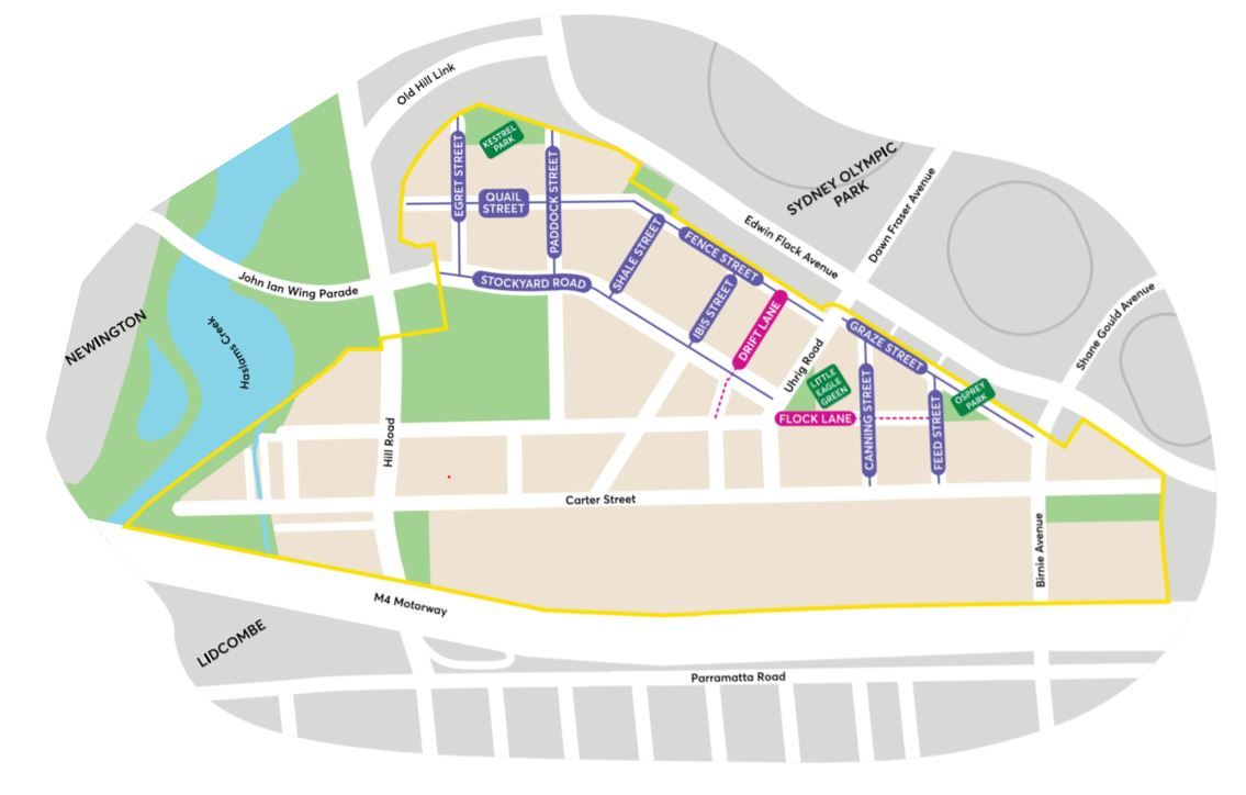
Since September 2016, a marginal area of the suburb of Lidcombe NSW belongs to the City of Parramatta Council Local Government Area and forms part of the Rosehill Ward. The majority of Lidcombe belongs to Cumberland Council. You can read our brief history of Lidcombe here
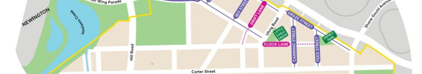
Based on what we have in records, researched as well as the Carter Street Precinct project where new names for roads, streets, lanes and open spaces have been proposed and gazetted, this is a list of how these streets in Lidcombe, Parramatta LGA got their names.
|
Name |
Origin & Meaning |
Source |
||
|
Birnie Avenue |
New road between Parramatta Road and Bachell Avenue approved by the Municipality of Lidcombe as Birnie Avenue on 6 February 1940. Road was extended replacing a section of Australia Avenue in Homebush Bay located between Parramatta Road and Edwin Flack Avenue on 16 September 1998 by the former Auburn Council (now Cumberland Council) |
Municipality of Lidcombe : Alteration of street names (1940, February 7). The Cumberland Argus and Fruitgrowers Advocate, p. 10. Council notices Auburn Council (1998, October 2). Government Gazette of the State of NSW, p. 8062. |
||
|
Canning Street |
The design and manufacture of tinned food cans was a production breakthrough in the late 1700s and early 1800s, allowing meat and other foods to be easily transported and preserved for longer periods. Alban Gee was a skilled technologist who came to Australia from England in 1866. He introduced advanced preserving techniques to many food companies in Australia, including the Sydney Meat Preserving Company. The Sydney Meat Preserving Company processed surplus stock for graziers, and sold its products in both Australia and Asia from its operations. The Company’s successful application of advanced technology made it a leader in food processing in Australia. Alban died in 1917 at his home at Homebush. He is recognised with the naming of Alban Street in Lidcombe. |
Farrer, Keith Thomas Henry (2005). To feed a nation: A history of Australian food science and technology, p. 35. Wayne, Michael. (2013, April 10). Past/Lives Flashback #8: Sydney Olympic Park – Homebush, NSW. In Past/Lives of the Near Future : Revealing traces of a former Sydney |
||
|
Carter Street |
Carter Street was part of Lidcombe before the 2000 Sydney Olympics, but later became part of Homebush Bay. On 2 October 2009, the suburb of Homebush Bay was dismantled into two new suburbs, Sydney Olympic Park and Wentworth Point, with Carter Street reabsorbed into Lidcombe. Part of the Homebush State Abattoir subdivision plan. Street name theme based on people connected with the meat industry. Carter Street is named after William John Carter, former President of the Australasian Meat Industry Employees Union and Meat Board chairman. Forms the major boundary for the Carter Street Precinct project started by the former Auburn Council before it was amalgamated into the City of Parramatta in 2016. |
State Library NSW (1878-1935) Plan of Proposed Subdivision of Part of Homebush Abattoirs, [Auburn subdivision plans], 411 - Z/SP/A10/398 Meat Industry Act, 1915-1960—by law. (1962, October 5). Government Gazette of the State of NSW, p. 2887. Workers in action (1964, July 29). Tribune, p. 12. |
||
|
Drift Lane |
A group of young pigs is called a drift, drove or litter. With the |
City of Parramatta Council. (2019). Carter Street Precinct : Naming the Roads, Streets, Lanes and Open Spaces. |
||
|
Egret Street |
The Eastern Great Egret is a tall white-feathered water bird, with a |
City of Parramatta Council. (2019). Carter Street Precinct : Naming the Roads, Streets, Lanes and Open Spaces. |
||
|
Feed Street |
Animals were given grains, hay, straw or other plants to feed on |
City of Parramatta Council. (2019). Carter Street Precinct : Naming the Roads, Streets, Lanes and Open Spaces. |
||
|
Fence Street |
Fences were used to keep animals in paddocks in the early farming |
City of Parramatta Council. (2019). Carter Street Precinct : Naming the Roads, Streets, Lanes and Open Spaces. |
||
|
Flock Lane |
A flock is a group of sheep or birds, usually more than two, that have congregated together. |
City of Parramatta Council. (2019). Carter Street Precinct : Naming the Roads, Streets, Lanes and Open Spaces |
||
|
Grazier Street |
Grazier refers to a person who raises cattle or sheep until they are grown and ready to sell at market. Graziers and other professions such as stockmen, butchers and drovers were vital to the meat industry. Many of the local residents in the area were highly-skilled and worked onsite or in pastoral and related meat industries. |
City of Parramatta Council. (2019). Carter Street Precinct : Naming the Roads, Streets, Lanes and Open Spaces |
||
|
Hills Road |
Part of the Homebush State Abattoir subdivision. Street naming theme based on people connected with the meat industry in the 1960s. Hills Road appears to be named after Phillip Stanley Hill, former member and from 1 January 1972, Chairman of the Metropolitan Meat Industry Board. |
State Library NSW (1878-1935) Plan of Proposed Subdivision of Part of Homebush Abattoirs, [Auburn subdivision plans], 411 - Z/SP/A10/398 Meat Industry Act, 1915-1960—by law. (1962, October 5). Government Gazette of the State of NSW, p. 2887. Workers in action (1964, July 29). Tribune, p. 12. |
||
|
Ibis Street |
The Australian White Ibis is a large bird with a white body, bald black head and black neck with a long curved black bill. Their natural habitat is terrestrial wetlands, grasslands and sheltered estuarine areas (where the river meets the sea) where they nest in trees and feed on frogs, crayfish, fish, crickets and beetles. Whilst Ibis populations are increasing in urban environments, populations across natural habitats are declining. |
City of Parramatta Council. (2019). Carter Street Precinct : Naming the Roads, Streets, Lanes and Open Spaces |
||
|
Kestrel Park |
Carter Street Precinct. Park named after carnivorous birds that have been sighted in the nearby parklands and wetlands including Sydney Olympic Park. |
City of Parramatta Council. (2019). Carter Street Precinct : Naming the Roads, Streets, Lanes and Open Spaces |
||
|
Little Eagle Green |
Carter Street Precinct. Wetland named after carnivorous birds that have been sighted in the nearby parklands and wetlands including Sydney Olympic Park. |
City of Parramatta Council. (2019). Carter Street Precinct : Naming the Roads, Streets, Lanes and Open Spaces |
||
|
M4 Motorway |
Since early 2013, the Roads and Maritime introduced a new road numbering system and new names for some important routes across the state network which includes a combination of a letter and a number from 1 to 99. ‘M’ stands for motorway. |
Wikipedia contributors. (2020). M4 Motorway (Sydney). In Wikipedia, The Free Encyclopedia |
||
|
Osprey Park |
Carter Street Precinct. Park named after carnivorous birds that have been sighted in the nearby parklands and wetlands including Sydney Olympic Park. |
City of Parramatta Council. (2019). Carter Street Precinct : Naming the Roads, Streets, Lanes and Open Spaces |
||
|
Paddock Street |
From the early establishment of farmland by European settlers, through to the late 1900s, sections of today’s Carter Street Precinct were once divided into paddocks and stockyards. |
City of Parramatta Council. (2019). Carter Street Precinct : Naming the Roads, Streets, Lanes and Open Spaces |
||
|
Parramatta Road |
Previous names: Sydney Road |
Wikipedia contributors. (2020). Parramatta Road. In Wikipedia, The Free Encyclopedia |
||
|
Quail Street |
The Brown Quail is a small ground-dwelling bird often difficult to spot. A shy bird, they prefer to hide in low-lying areas next to wetlands or in grasslands and will often flee when approached. |
City of Parramatta Council. (2019). Carter Street Precinct : Naming the Roads, Streets, Lanes and Open Spaces |
||
|
Shale Street |
The land spanning the precinct and surrounds has a soil composition of shale soils (fine grain rock). Wianamatta shales easily support the growth of native vegetation, however harvesting crops such as vegetables can prove difficult. When early settlers attempted to cultivate crops on the land, the shale soils quickly lost their fertility. Livestock became the predominant resource as the soils were too poor for agriculture. |
City of Parramatta Council. (2019). Carter Street Precinct : Naming the Roads, Streets, Lanes and Open Spaces |
||
|
Stockyard Road |
Stockyard Road is named after the many stockyards that were associated with the NSW State Government abattoirs. According to the Conservation Management Plan for the Abattoir Heritage Precinct at Sydney Olympic Park, the State Abattoirs moved from Glebe to Homebush in 1907 and closed in 1988. It was Australia’s largest abattoir during this period, responsible for the centralised control of meat processing, sale and distribution in Sydney. The abattoirs were associated with 1,500 acres (607 hectares) of stockyards, used for holding and sorting cattle, pigs, goats and sheep from the Flemington saleyards nearby |
City of Parramatta Council. (2019). Carter Street Precinct : Naming the Roads, Streets, Lanes and Open Spaces |
||
|
Uhrig Road |
Part of the Homebush State Abattoir subdivision. Street named based of people connected with the meat industry. Uhrig Road is named after Leslie Earl Uhrig (died 2 December 1974), producers' representative, and elected member of the Metropolitan Meat Industry Board until his death. |
State Library of New South Wales (1878-1935) Plan of Proposed Subdivision of Part of Homebush Abattoirs, [Auburn subdivision plans], 411 - Z/SP/A10/398 Meat Industry Act, 1915-1960—by law. (1962, October 5). Government Gazette of the State of NSW, p. 2887. Workers in action (1964, July 29). Tribune, p. 12. Meat Industry Act, 1915-1965—by law. (1966, April 22). Government Gazette of the State of NSW, p. 1690. |

Anne Tsang, Research Assistant and Neera Sahni, Research Services Leader, Parramatta Heritage Centre, City of Parramatta, 2020.
Disclaimer: we have tried our best to provide a reason behind how these public roads and streets in Wentworth Point listed got their names but should there be any discrepancies or if you can help us fill in the gaps, please contact us using our online enquiries form.
References
City of Parramatta Council. (2019). Draft local strategic planning statement. Retrieved from https://eppingcivictrust.org/wp-content/uploads/2019/10/draft-lsps_-_exhibition_copy.pdf
City of Parramatta Council. (2019, August 14). Help name streets in Lidcombe’s new Carter Street precinct [Media release]. Retrieved from https://www.cityofparramatta.nsw.gov.au/about-parramatta/news/media-release/help-name-streets-in-lidcombes-new-carter-street-precinct
City of Parramatta Council. (2019). Carter Street Precinct : Naming the Roads, Streets, Lanes and Open Spaces. Retrieved from https://oursay-files.s3-ap-southeast-2.amazonaws.com/production/fm/osp-ug-73/carter_street_precinct/bth00376_communitysummary_epub_v12.pdf#page5
Kass, Terry. (2008). Lidcombe. In Dictionary of Sydney. Retrieved from http://dictionaryofsydney.org/entry/lidcombe
Lidcombe subdivision plans [cartographic material]. (1879). Sydney, NSW: Various. Retrieved from https://search.sl.nsw.gov.au/permalink/f/19q252h/SLNSW_ALMA21140417040002626
State Library of New South Wales. (2010). List of Lidcombe subdivision plans. Retrieved from https://www2.sl.nsw.gov.au/content_lists/subdivision_plans/lidcombe.html