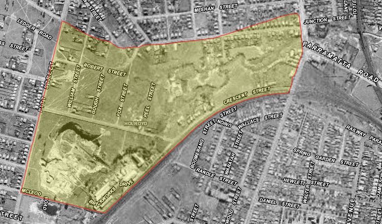
Holroyd is a small western Sydney suburb located in the Cumberland Council local government area (Granville ward) and a small section being part of the City of Parramatta Council LGA (Rosehill ward) as indicated in the map below. It is bordered by the M4 Western Motorway as the northern boundary, Church Street, Woodville Road and the rail line as the eastern boundary, Neil Street to the south and Pitt Street to the west.[1]
Traditional custodians
For tens of thousands of years before European settlement, the Cumberland plain area was home to several clans of the Darug people (also spelt Dharug, Daruk or Dharik). There were three distinct dialects in the Darug territory – the coastal, the hinterland (or Cumberland plains) and the mountains. Given the location of Holroyd, the Burramattagal clan of the Darug nation who occupied the Parramatta and Granville area and the Bidjigal clan which occupied the areas now known as Merrylands, Guildford, Villawood and Bankstown appear to be the traditional Darug people living and hunting in the area.[2]
Two important Aboriginal sites can be found in Union Street, Granville, and Carhullen Street Merrylands. Evidence at these sites identify the areas as ‘Paiendra’, meaning members of the inland culture who specialised in hunting possum. The evidence suggests that these Darug members had links with the Dharawal and Gundungurra tribes of the south and south-west.[3]
A’Beckett’s Creek near the junction of Woodville Road and Union Street, Granville was used by Aboriginal clans from the south as a campsite during the annual conference initated by Governor Lachlan Macquarie in 1814 to local Aboriginals to come to the market place (now Centenary Square) at Parramatta where a dinner would be offered to all who made the trek.[4]
Early European settlement
In 1855, Arthur Todd Holroyd (1806-1887) [5] acquired Sherwood Scrubs, Merrylands
Municipality of Prospect and Sherwood (1827-1927)
On 5 July 1872, the Municipal District of Prospect and Sherwood was incorporated. In 1906, it was renamed Municipality of Prospect and Sherwood (1906-1927).

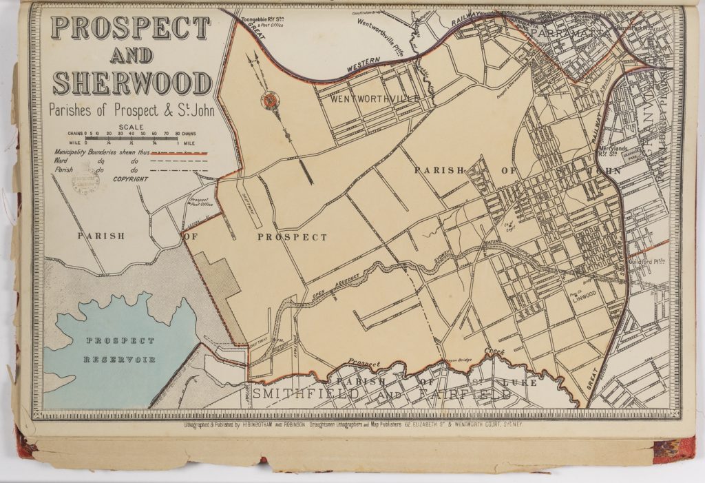
Municipality of Prospect and Sherwood. In Higinbotham & Robinson, 1889-1894. Atlas of the Suburbs of Sydney)Sydney suburban borough maps. (Source: State Library of NSW, file number FL4501752)[6]
It had an area of 39.9 square kilometers, making it one of the largest municipalities in Sydney. The area included the modern suburbs of Girraween, Greystanes, South Wentworthville, Mays Hill, Holroyd, Merrylands West, Guildford West, Woodpark and parts of Pendle Hill, Wentworthville, Westmead, Granville, Merrylands, Guildford, Yennora, Smithfield and Prospect.[7]
From 1915, Council Chambers was located in Merrylands West.
Municipality of Holroyd (1927-1991)
On 11 January 1927, the Prospect and Sherwood Municipality changed its name by proclamation of the Governor to Municipality of Holroyd. Holroyd was choosen in honour of the area’s first mayor, and prominent local figure, Alderman Judge Arthur Todd Holroyd. Pressure from the Local Government Association and the postal authorities.
The name Prospect and Sherwood was considered too cumbersome and there was the added complication of another small locality called Sherwood, near Kempsey.
The first council chambers at Mays Hill were too small and there was public interest to build another closer to the Municipality’s main population centre at Merrylands West. [8]
The Holroyd Administration Centre was officially opened by the New South Wales Premier Bob Heffron on 19 June 1962 in Merrylands.
Holroyd City Council (1991-2016)
From 1 January 1991, Holroyd was granted city status, becoming the Holroyd City Council.
On 10 June 1994, the Holroyd Gardens Development was gazetted. It was formerly the site of the historic Goodlet and Smith Brickpit and comprised an area bordered by Neil Street, Pitt Street, Walpole Street and the rail line.
In 1999, the suburb of Holroyd was created when the New South Wales Geographical Names Board sought to define suburb boundaries. The Holroyd Council local government area did not have a specific suburb of the same name and had to create one to satisfy the State Government requirements. The suburb named Holroyd was gazetted on 15 October 1999, with boundaries being Walpole Street (north), Neil Street (south) the railway line (east) and Pitt Street (west). This suburb had also been known as Granville West and Merrylands. The boundary changed in 2001 with the northern boundary extended to the M4 Western motorway.
Research Library Collection
Below are some of the resources held in the Research Library related to Holroyd (N.S.W.):
The Jubilee history : Municipality of Prospect and Sherwood 1872-1922
(Also known as “Where every prospect pleases” : Jubilee souvenir, Municipality of Prospect and Sherwood.)
/ by Freame, William, 1867-1933.
Publication details: Parramatta, N.S.W.: Council of the Municipality of Prospect and Sherwood, 1922
Summary: This book contains history of the Council, 1922 photos of Council and staff as well as historical notes on the suburbs Greystanes, Girraween, Guildford, May’s Hill, Merrylands, Pendle Hill, Wentworthville and Westmead that made up the municipality. It also includes details on the soldier’s memorial and advertisements of local businesses.
Call number: LS 994.41 FRE
Holroyd centenary, 1872-1972
/ by Ruhen, Carl, 1937-2013.
Publication details: Cammeray, N.S.W. : Horwitz for Holroyd Municipal Council, 1972.
Call number: LS 994.41 HOL
Parramatta and Holroyd Mercury Newspaper [microfilm]
Publication date range: 1977 – 1995
Call number: MICROFILM DRAWER
Highlights of Holroyd
/ prepared by Holroyd Historical Society.
Publication details: Pendle Hill, N.S.W. : Holroyd Historical Society, 1979.
Call number: LS 994.41 HIG
Holroyd : a social history of Western Sydney
/ by Karskens, Grace.
Publication details: Kensington, N.S.W. : NSW University Press, 1991.
Call number: LS 994.413 KAR
Parramatta Sun Newspaper [microfilm]
(Later known as Parramatta Holroyd Sun)
Publication date range: 1995 – 2017
Call number MICROFILM DRAWER
Holroyd history and the silent boundary project : a research report
/ by Flynn, Michael C.
Publication details: [Merrylands, N.S.W. : Holroyd City Council], 1997.
Call number: LS 994.411 FLYN
Holroyd happenings : newsletter of Holroyd Family History Group.
/ by Holroyd Family History Group.
Publication date range: 1998-2015
Publication details: [Merrylands, N.S.W. : The Group], 1998-2015.
Call number: LS BOX 994.4105 HOLR STACK – Please make an appointment with Library staff for access
Holroyd and District Historical Society 19th annual report 2001 : celebrating the Centenary of Federation
/ by Holroyd and District Historical Society (Holroyd, N.S.W.)
Publication details: [Merrylands, N.S.W. : The Group], 2001.
Call number: LS 994.41 HOLR
Holroyd : Girraween, Greystanes, Guildford, Mays Hill, Merrylands, Pemulwuy, Pendle Hill, Prospect, Smithfield, Toongabbie, Wentworthville, Westmead, Woodpark, Yennora
/by Elias, Jane, author.
Publication details: Alexandria, NSW : Kingsclear Books, 2013.
Call number: LS 994.41 ELIA
Holroyd city : heritage item
/ by Holroyd (N.S.W.) City Council.
Publication details: [Merrylands, N.S.W. : Holroyd City Council, 2015]
Call number: LS 363.69099441 HOLR
General suburb resources:
Sydney and suburbs : a history & description
/ by Kennedy, Brian, 1937- & Kennedy, Barbara.
Publication details: Frenchs Forest, N.S.W. : Reed, 1982.
Call number: LS 994.41 KEN
The book of Sydney suburbs
/ compiled by Pollon, Frances, 1923- ; original manuscript by Healy, Gerald.
Publication details: Sydney : Angus & Robertson, 1988.
Call number: READY REFERENCE LS 994.41 BOO
Anne Tsang, Research Assistant, Parramatta Heritage Centre, City of Parramatta, 2020
References
[1] Cumberland Council. (2019). History of the suburbs : Holroyd. Retrieved from https://www.cumberland.nsw.gov.au/history-suburbs
[2] Cumberland Council. (2019). History and land. Retrieved from https://www.cumberland.nsw.gov.au/history-and-land ;
Cumberland Council. (2019). Holroyd Sports Ground plan of management : Public exhibition draft. Retrieved from https://haveyoursay.cumberland.nsw.gov.au/45921/documents/105221 OR http://cumberland.infocouncil.biz/Open/2019/05/C_15052019_AGN_2601_AT_files/C_15052019_AGN_2601_AT_Attachment_6655_1.PDF
[3] Cumberland Council. (2019). Aboriginal heritage in Cumberland. Retrieved from https://www.cumberland.nsw.gov.au/aboriginal-heritage-cumberland ;
[4] Western Sydney Libraries. (no date). Dharug. Retrieved from http://www.westernsydneylibraries.nsw.gov.au/westernsydney/dharug.html ;
Betteridge Consulting Pty Ltd
(2019). Heritage Interpretation Strategy for Western Sydney Stadium,
p. 43. Retrieved from https://bankweststadium.com.au/wp-content/uploads/2019/04/WSS-Heritage-Interpretation-Strategy-8-April-2019.pdf ;
Australia for Everyone. (2019). Waterways: south and southwest. In Pocket Oz travel & information guide: Sydney. Retrieved from http://www.visitsydneyaustralia.com.au/waterways-west.html
OR Australia for Everyone. (2019). Geographical features: Parramatta River. In Pocket Oz travel & information guide: Sydney. Retrieved from http://www.visitsydneyaustralia.com.au/names-parramatta-river.html
[5] Arthur Todd Holroyd (1806-1887). Retrieved from http://adb.anu.edu.au/biography/holroyd-arthur-todd-3783
[6] Prospect and Sherwood. In Sydney suburban borough maps, file number FL4501752. Retrieved from State Library of NSW
[7] Wilson, Andrew. (2012). Atlas of the Suburbs of Sydney In Dictionary of Sydney. Retrieved from https://dictionaryofsydney.org/entry/atlas_of_the_suburbs_of_sydney
[8] Pictorial history of Holroyd, p.83.
[9] Wikipedia contributors. (2019). Holroyd, New South Wales. In Wikipedia, The Free Encyclopedia. Retrieved from https://en.wikipedia.org/wiki/Holroyd,_New_South_Wales


